3D Laser Scanning for Ships: How It Works and Why the Marine Industry Is Adopting It
The marine industry is undergoing incredible change due to increasing demand for precision, safety and efficiency in shipbuilding, repair and offshore.Traditional methods of surveying do not provide satisfactory results when it comes to complex shapes and structures or tight timelines on projects. 3D laser scanning of ships has created new ways to execute our marine projects.
Using 3D Laser Scanning and Modeling, shipyards, offshore operators and engineering teams can create extremely accurate digital representations of vessels/structures and use those digital models to improve decision making, reduce/removal of wasteful work and improve overall operational efficiency.
In this post, we will explore how 3D Laser Scanning for ships work, what the benefits of using digital models are and how it has become standard solutions transforming the Marine Industry.
What is 3D Laser Scanning for Ships?
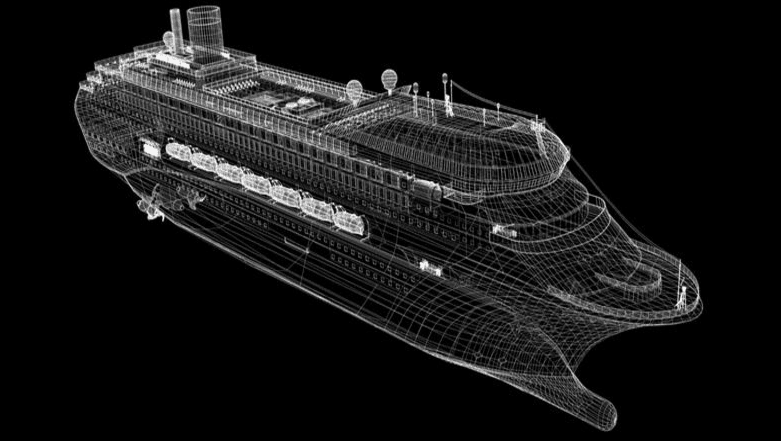
3D laser scanning for ships utilizes lasers and sensors to capture millions of accurately measured locations on a ship's structure, creating a point cloud which can be used for the generation of models in 3D CAD or Building Information Model (BIM) format. The resultant data collected using laser scanning technology on a ship will allow engineers to create detailed documentation of each component of the ship with an accuracy of millimeter such that each component can be used to design, retrofit and maintain the ship. Thus, using laser-scanned data removes uncertainty and creates a solid foundation of information to design, retrofit and perform maintenance of ships.
How 3D Laser Scanning Works in Marine Projects
1. Data Capture
Laser scanners are located throughout a ship to gather complete geometry of the vessel. Advanced 3d scanning services allow an entire ship to be scanned in a few hours or a few days depending on the size.
2. Point Cloud Generation
The scanner collects millions of data points to create a dense volume of point cloud data, which is a representation of the ship's structure.
3. Data Processing
Using 3d scanning and modeling services, the point cloud is processed and prepared for further refinement into a usable digital model.
4. Model Creation
The processed data will be converted into CAD or BIM format using bim modelling services in India. This will provide the necessary level of detail needed for accurate design and installation.
Why the Marine Industry is Adopting 3D Laser Scanning
1. High Accuracy and Precision
Using 3D laser scanning for ships results in millimeter accuracy, making it great for aquatic structures where measurement is vital.
2. Reduced Downtime
Traditional surveying can take many days to weeks; however, with 3D scanning service, there will be less downtime during drydock.
3. Improved Safety
Scanning is a non-invasive method and will allow engineers to safely obtain data from dangerous, tight locations.
4. Better Retrofit and Maintenance Planning
With the digital model being accurate this allows engineers to finally plan upgrades to the design of a ship without using outdated plans.
5. Enhanced Collaboration
The digital models created from 3d laser scanning and modeling will provide coordinating designs between the design, engineering and operational departments an easier means of working together.
Key Applications of 3D Laser Scanning for Ships
Ship Retrofitting and Upgrades
includes creating accurate models for different new parts to guarantee their proper fitting within existing structures.
Dry Dock Inspections
The shipyards perform dry dock inspections on all ships that utilize 3d laser scanning for ships to document the condition of each vessel during its maintenance lifecycles.
Offshore Platform Documentation
The technology is also widely used in 3d laser scanning for oil and gas projects involving offshore assets.
Clash Detection
Engineers can also complete clash detection by overlaying their new designs onto their existing models to detect conflicts prior to the installation.
As-Built Documentation
As-built documentation services in UAE and As-built documentation service in MENA region are a good way for companies to keep accurate records of their vessel structures.
3D Laser Scanning vs Traditional Marine Survey Method
| Feature | Traditional Survey |
3D Laser Scanning |
| Accuracy | Moderate |
High (mm-level) |
| Time | Days/Weeks |
Hours/Days |
| Safety | Risky |
Non-contact |
| Data Quality | Limited |
Complete 3D capture |
| Rework | High |
Minimal |
Marine companies worldwide are increasingly partnering with 3d laser scanning companies in India, 3d laser scanning companies in UAE, and 3d laser scanning companies in MENA Region to access high-quality and cost-effective services.
Cities like Bangalore are emerging as hubs for 3d laser scanning and modeling in Bangalore and 3d scanning services in Bangalore, supporting global marine and offshore projects.
Additionally, technologies like drone surveying services in Bangalore are complementing scanning workflows for large-scale marine infrastructure mapping.
Choosing the Right 3D Scanning Company
When selecting a 3d scanning company, consider:
- Experience in marine projects
- Availability of advanced scanning equipment
- Expertise in 3d scanning and modeling services
- Ability to deliver BIM and CAD outputs
- Presence in key regions like India and UAE
- Working with reliable 3d scanning companies ensures high-quality data and successful project execution.
Conclusion
As the marine industry continues to embrace digital transformation, 3d laser scanning for ships is becoming an essential tool for accurate documentation, efficient project execution, and improved safety.
With the support of advanced 3d laser scanning services UAE, global providers, and expert 3d scanning services, companies can streamline operations and reduce costs while maintaining high levels of precision.
The future of marine engineering lies in adopting technologies like 3d laser scanning in India and beyond, enabling smarter, faster, and safer project workflows.
FAQs
1. What is 3d laser scanning for ships?
It is a technology that captures precise 3D measurements of ships using laser scanners to create accurate digital models.
2. How accurate is 3d laser scanning?
Modern scanners provide millimeter-level accuracy, making them highly reliable for marine engineering projects.
3. How long does it take to scan a ship?
Depending on size, scanning can take from a few hours to several days.
4. What is a point cloud?
A point cloud is a collection of millions of data points that represent the geometry of a scanned object.
5. Can 3d laser scanning reduce project costs?
Yes, it reduces errors, minimizes rework, and speeds up project timelines.
6. Is laser scanning safe for marine environments?
Yes, it is a non-contact method that allows safe data collection in hazardous areas.
7. How does laser scanning support BIM?
It provides accurate data that can be converted into BIM models for design and planning.
8. Which industries use 3d laser scanning besides marine?
Industries include construction, oil & gas, manufacturing, infrastructure, and VFX (via 3d laser scanning and modeling for VFX).
9. What should I look for in a scanning provider?
Choose experienced 3d scanning companies with expertise in modeling, BIM, and industry-specific projects.
10. How often should ships be scanned?
Ships should be scanned during major maintenance cycles, retrofits, or inspections to maintain accurate documentation.
#3DLaserScanningforship #3dscanningandmodelingservice #3dscanningcompanies #3dlaserscanningcompaniesinMENA Region #As-builtdocumentationservicesinUAE #3dscanningservices